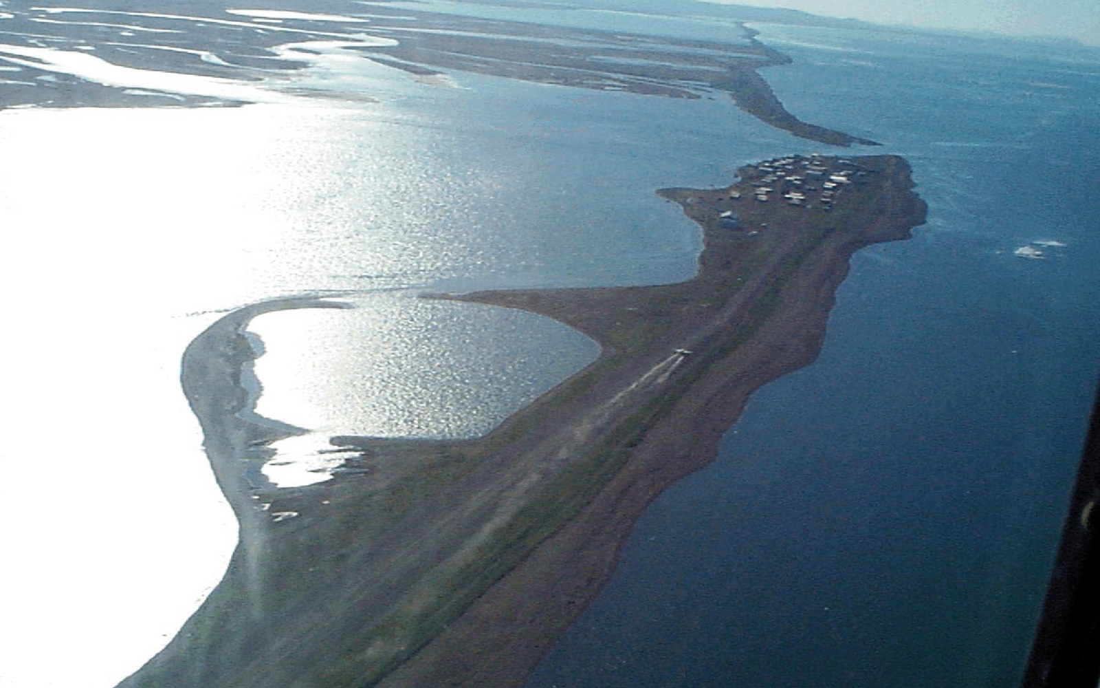
Where the island sits and why it is there
Kivalina occupies a narrow gravel barrier island at the mouth of the Wulik River, where the river meets the Chukchi Sea on Alaska's northwest coast. The island is roughly ten kilometres long and, at its narrowest, not much more than a hundred metres wide. On one side is the open sea; on the other, a lagoon. The position was practical for the same reasons that made barrier islands attractive to coastal settlements everywhere: proximity to open water and a protected inside passage, a staging point between river and sea, access to both environments in a single place.
The gravel itself arrived the same way the river's channel was built — carried down from the De Long Mountains, deposited at the coast, reworked by longshore drift. The island is not bedrock; it is unconsolidated sediment held in shape by wave energy and ice. For most of the year, shorefast ice — the seasonal sea ice that freezes fast to the shore — armoured the seaward face against autumn and winter storm waves. The barrier island was geomorphically stable within that regime.
What has been changing, and how it is measured
The record of Kivalina's coastal erosion is documented annually by the US Geological Survey and the Alaska Division of Geological and Geophysical Surveys. What the measurements show is that the island has been losing width on both the seaward and lagoon-facing sides. Erosion rates along this stretch of the Chukchi Sea coast are among the highest recorded in Alaska, with some segments losing several metres per year. The specific numbers have varied year to year, but the cumulative loss over decades is substantial, and it runs in one direction.

Multiple agency studies have examined moving the village, and the record of those studies is itself the clearest account of why it has not happened. Relocation has been studied since the 1990s
The mechanism is not new but its intensity has increased. Storm waves arrive when the sea is open water. Shorefast ice historically formed early enough to protect the coast through the main storm season, but that timing has shifted: the ice now forms later in autumn, leaving the coast exposed during the period when storms are most frequent and most powerful. A gravel barrier island that is unarmoured by ice and hit repeatedly by storm waves loses material. Some of it washes into the lagoon; some of it is carried offshore. It does not come back in any form that adds to the island's width.
The island is also low. There is no high ground to retreat to. Buildings sit on gravel pads — thick fills of graded aggregate that keep structures elevated and thermally isolated from the permafrost beneath — but elevation above sea level is a fixed constraint that no engineering on site can change. Storm surge events push water across the lowest points of the island, and the record of those events is part of what the relocation studies have used.
The studies, the decisions, and where the process stands
The question of whether and where to relocate Kivalina has been under formal study since at least the 1990s. The Army Corps of Engineers, working under its Alaska District, produced assessments identifying the village as among a set of Alaska Native communities facing the most urgent erosion threats. A 2003 report by the Government Accountability Office named Kivalina specifically as a community where erosion threatened structures and where relocation was under consideration. Subsequent studies by state and federal agencies added hydrological, geotechnical, and cost analysis.
The complication was never that the problem was unrecognised. It was that relocation is expensive at a scale that dwarfs what any single program was funded to provide, and that the decision of where to go required agreement among residents, the tribal council, the City of Kivalina, and the various agencies that held permitting authority or funding streams. A preferred relocation site — on higher ground inland, away from both the coast and the island — was identified and has remained the subject of planning. The decision to relocate has been formally endorsed by the community's governing bodies.
A gravel barrier island that is unarmoured by ice and hit repeatedly by storm waves loses material.
The school bears particular weight in the logistics. In a settlement of several hundred people, the school is the largest building, the largest capital investment, and the institution around which other infrastructure organises. Moving it requires federal and state education funding that operates on its own timeline, separate from erosion-emergency funding. Until the school moves, the full relocation cannot be said to have happened in any practical sense.
What the mine and the road have to do with it
The Red Dog Mine sits at the head of the Wulik, roughly ninety kilometres inland. Its existence has shaped Kivalina's immediate surroundings in a specific way: the DeLong Mountain Transportation System road, built to carry zinc concentrate from mine to coast, ends at a port facility just south of the village. The port serves the mine's shipping season, which runs for roughly one hundred days when the Chukchi is ice-free. Kivalina's residents have had employment access to mine-related work that would not otherwise exist at this location.
The stretch this piece is about: Kivalina at the mouth, Red Dog at the head, the De Long Mountains behind both.
Geometry: project map kit
The NANA Regional Corporation, which holds land across the region under the framework established by the Alaska Native Claims Settlement Act of 1971, is a landowner across this territory and a party to the mine operating agreement. The relationship between NANA, the operating company Teck Alaska Incorporated, and the communities in the watershed is a matter of formal corporate and governmental agreement, not informal arrangement. How the relocation is funded, what land is available for the new site, and who controls the permitting process all run through that layered structure of federal, state, NANA and local authority.
The port infrastructure itself will not move with the village. It was built to serve the mine, not the settlement, and its position is determined by the mine road's terminus and the offshore bathymetry that dictates where concentrate barges can be lightered out to waiting vessels. Whatever happens to the village, the industrial geography of this coast is fixed by those constraints.
The island now
The physical situation as the record describes it: a barrier island losing width from both sides, with storm exposure increasing as shorefast ice forms later each year, populated by a community that has formally decided to relocate but has not yet completed the move, dependent in part on employment tied to an industrial operation that will remain at the coast regardless of where the village ends up.
The island will not stabilise. The processes removing it are not cyclical in any timeframe that matters to infrastructure or to a school. The question in the documented record has moved from whether the situation is serious to when the funding and the logistics will align.